


Development of High-Frequency Optical Observation System and case studies
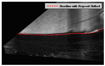
WP-4. One of the innovations of the project is the development of a low cost, autonomous, high frequency monitoring system (AOMS) (WP-4.1). The system will consist of integrated video cameras suitably located, calibrated and geo-referenced (e.g. Alegría-Arzaburu et al., 2010), which will record (2-D) the coastline locations, wave breaking zones and wave run-ups in frequencies of up to ~30 Hz (Vousdoukas et al., 2009b). New algotithms/techniques will be developed with regard to motion detection and recognition (e.g. Vousdoukas and Conley, 2008), whereas the system will be able to record the initial ‘raw’ optical data as well as final morphological time series (meta-data) at suitable temporal scales). Following trials, the AOMS will be deployed at the 2 case study island beaches (Lesbos and Mykonos) for the collection of long-term morphological data. As beach morphodynamics are also controlled by sediment supply, the riverine discharges (and their extremes) and the flood curves of the drainage basins associated with the 2 case study beaches will be assessed, through flow/sediment discharge modeling (e.g. Velegrakis et al., 2008; Lekkas, 2008), calibrated and validated by short-term flow/sediment discharge observations at suitable locations (obtained using the flow and suspended sediment sensors owned by the RGs, e.g. sideward looking ADCPs, OBSs etc) (WP-4.2). It is envisaged that the findings of the project will improve considerably the assessment of the hydrological dynamics of small island drainage basins.
High resolution remote sensing information (e.g. IKONOS, Quickbird) will define the coastline at the case study beaches and give information on beach sediments (WP-4.3). The satellite information will be then compared with information from the AOMS and RTK-GPS surveys, taking also into account other information (nearshore high frequency hydrodynamic and sediment dynamic observations and swash zone pore pressure observations) that will be collected concurrently with satellite information (WP-4.4). It is envisaged that this will result in an improved assessment of the satellite information accuracy and a better image definition of the nature of the beach sediments. In addition, swash zone wave rup up and pore pressure observations will be combined with infiltration/exfiltration modeling (e.g. Karambas, 2003) to improve our knowledge on this important process.
Includes the following Tasks and its Deliverables (D):
- 4.1 Development and installation of the optical observation system
- D-15. Developemt of optical monitoring system (AOMS) (technical Report)
- 4.2 Riverine sediment supply to case study beaches
- D-16. Case study drainage basin study (technical Report)
- 4.3 Satellite data: Coastline detection and its controls and error estimations
- D-17. Satellite imagery calibration (technical Report)
- 4.4 Collection/analysis of field data hydrodynamic and optical data
- D-18. Field experiments (technical Report)
Coastline determination using coastal imaging tecniques and neural networks

